Full work days of the 2019 season started on Thursday. This year, we’re digging three trenches. Staff laid out trenches earlier in the week, identifying areas they expect to reveal different aspects of the site. We use GPS devices to mark the perimeters of the trenches, and points will be taken throughout the season to precisely locate finds and features in the trenches and assist in analyzing the site.
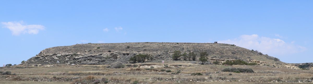
The site of Vigla, which sits on a prominent plateau overlooking Larnaca Bay, was likely a Hellenistic fortification, built sometime after Alexander the Great’s empire expanded throughout the Eastern Mediterranean region, including Cyprus. The fortified area at Vigla may provide evidence of a time when the center of power shifted from local city-kingdoms to external imperial rule.
The north trench is located to the east of the trench dug during the 2018 field season, which revealed a large mudbrick wall which sits on ashlar masonry block. Although previous surveys had identified a fieldstone fortification wall surrounding the plateau, the mudbrick and ashlar construction had not been known at the site prior to the 2018 season. The current trench is set up to catch both sides of the wall so that we can excavate the interior face of the wall, which was not revealed during the 2018 season.
Excavating mudbrick is no easy task! Fallen mudbrick that has deteriorated in the elements is very hard, and it’s difficult to pick out individual bricks. Time for the pickaxe!

The middle trench is located in the center of the plateau. We hope that this large trench will provide evidence about the occupants of the fortified area, about whom little is known. We suspect that the occupation was military in nature due to finds in previous test excavations including bronze projectile points, lead sling bullets, and evidence of small-scale weapons manufacture.
The south trench is located directly over the south fortification wall, which was partially visible even before excavation. This trench will help to identify how what appears to be a fieldstone wall was constructed and its relationship to the north wall revealed in 2018, which appears to be of entirely different construction.

Within a given trench, archaeologists excavate individual stratigraphic units. A stratigraphic unit is a layer of soil which, in the context of archaeological fieldwork, represents the results of a specific set of human activities in the past. For example, the first stratigraphic unit in the middle trench was topsoil and recent vegetation lying on top of a hard layer of plow marks, the result of past cultivation. The plow marks form the top of the second stratigraphic unit.

As each stratigraphic unit is removed, any artifacts are collected, bagged and labeled for further analysis. To aid in this, we sieve all soil and to expose any small artifacts. At a site like Vigla, these are almost entirely pottery sherds.

At the close of each stratigraphic unit, the team records information about the unit, which is later entered into a database to aid in analysis. This information may include descriptions of the soil and finds, measurements, photographs, and drawings of any architectural features. As part of the field school, students learn how to properly collect and record this data.
